Have you ever wondered about the daily life of a particular ancestor? What did their home look like? What about the street they lived on? What kind of shops, houses, or other buildings did they pass by every day? How far did they walk to their place of worship, or their job?
Believe it or not, this kind of information is within reach if you can locate a fire insurance map that covers their time and place.
Fire insurance maps are some of the most detailed and fascinating historical maps available and they are particularly useful for genealogists - not only can you use them to vividly recreate the world of your ancestors, but information gleaned from these sources can also lead to discoveries.
This article takes a look at fire insurance maps and how you may incorporate them into your research. It will cover:
- A brief background of fire insurance maps
- Items of interest on fire insurance maps
- Places to find fire insurance maps on the web
Via Wikimedia Commons
Fire Insurance Maps: A Brief Background
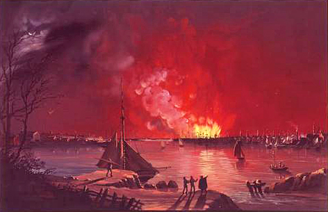
In the 1800s, fire was an enormous risk in urban areas. After the Great Fire of New York in 1835 (there were also well-known "Great Fires" in 1776 and 1845) caused millions of dollars in damages, nearly all of New York's insurance companies went out of business.
This great event brought about many changes to New York City, and one was the way buildings and property were underwritten by insurers. According to the New York Public Library, William Perris, an English-trained civil engineer and surveyor was the first one to create modern fire insurance maps of New York. These maps detailed everything an insurer would need to know to underwrite a particular piece of property, including the exact construction and features of each building, the use and purpose of each building, details about the surrounding streets and urban environment, and more.
Several companies produced maps like this from the mid-1800s until the 1970s. During the 1900s, the most prolific publisher of these maps was the Sanborn Map Company, which operated a near-monopoly during the twentieth century. For this reason, you'll hear many refer to these maps as "Sanborn Fire Insurance Maps" or just "Sanborns."
This handy interactive display from the Digital Library of Georgia will highlight some aspects of fire insurance maps, but is by no means an exhaustive list of everything that the maps describe - complete keys to each map are typically included with the preserved copies. Hover your mouse over the map or list of features below to see how they are displayed.
The best way to get familiar with this kind of map is to explore - read on to learn some ways family history researchers can use them in their research, and where to find the best online collections of fire insurance maps.
Items of Interest on Fire Insurance Maps
If you explored the interactive diagram above, you can see that there is a lot of very specific information included in these maps. Not all of this information is of immediate use to the family history researcher, though many of the details can be used to color a written narrative in a family history or biographical sketch with amazing (and accurate!) detail.
Below you will find a selection of items that are of particular interest to a family history researcher. The examples are general and the list is certainly not exhaustive - the beauty of these maps is that they are as unique as each community they reflect. The best way to get to know fire insurance maps is to explore for yourself.
Places of Residence
The most numerous buildings seen on many fire insurance maps are residential buildings. The maps often contain interesting details about the architectural features of these buildings, but perhaps more useful are the clearly marked building numbers.
Street numbering systems change over time, so knowing a building's exact address at a given time in history can be valuable for the researcher. There's always a chance that plugging a historical address into a modern map will give you an inaccurate location, so consulting a fire insurance map close to the date of interest will give a more accurate picture.
The best option is to take advantage of a digitized, georeferenced version of the fire insurance map and view it overlaid on a modern map interface.

With a few tools, this is easily achievable - read our Google Earth of Genealogy series for detailed instructions (Part 2: Adding Historical Maps & Data covers importing fire insurance maps).
Religious Congregations
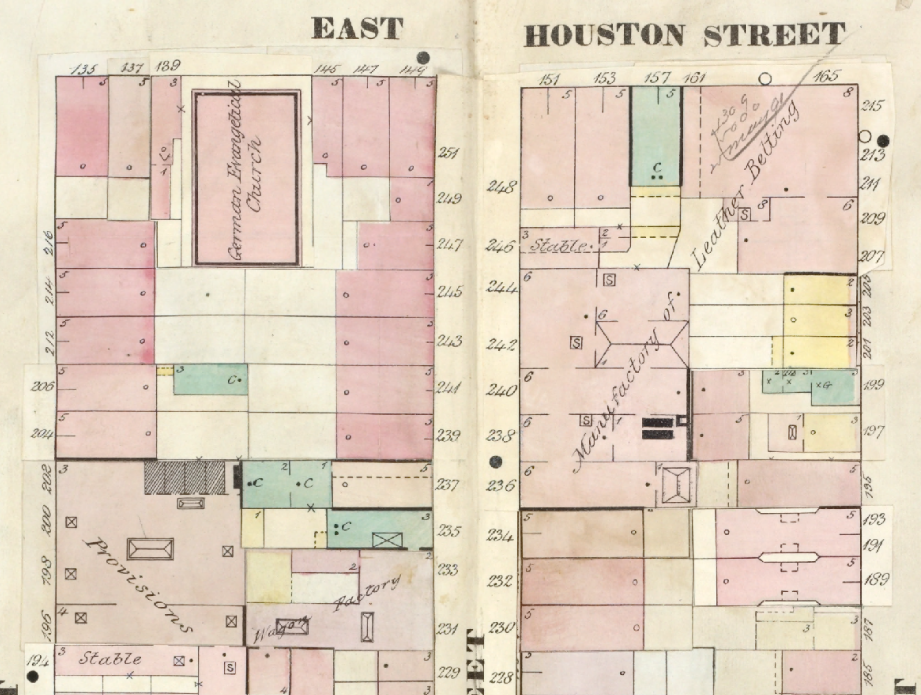
The buildings of religious congregations are clearly marked on insurance maps, and churches will usually have their denomination indicated. Below you can see four churches found on just one plate of a fire insurance map from the Lower East Side of Manhattan in 1857.
Note that the specific name of the church is not included, but the surrounding streets and addresses should allow you to discover the name of the church with a little further research.

Our ancestors typically lived close to their religious congregations, so locating all congregations around your ancestor's place of residence is a good strategy to locate records like baptisms, marriages, burials, or more. Religious records serve as excellent vital record substitutes for New York State researchers - civil birth, marriage, and death certificates can be challenging to find in New York State.
Places of Employment and Commerce
Businesses and other buildings involving commerce and industry are generally well-marked on fire insurance maps. A very common question we get from our members is how they can learn more about the occupations of their ancestors. This is a tricky research goal, and there isn't any single method that can solve all problems, but fire insurance maps can help in some instances.
If you know your ancestor's occupation, seeing what shops and businesses were close to your ancestor's residence can help you form some hypotheses about exactly where they may have worked. Like with religious congregations, by using the street addresses of historical businesses, you may be able to learn more with additional research.
Take a look at the numerous buildings of interest from a portion of Ward 17 in the Lower East Side of Manhattan:

Researchers with ancestors who have related occupations would be very interested to see these buildings. If nothing else, the non-residential buildings in an area can give you a feel for the neighborhood.
Using the above example, we know from our demographic study of Ward 17 in the 1855 New York State census that there were a lot of German immigrants in this neighborhood. The number of breweries, a German school, and a theater that often featured German actors (New York Volks' Theatre) indicates there may have been a lot of German immigrants in this specific section of Ward 17
Where to Find New York State Fire Insurance Maps Online
One thing to keep in mind is that fire insurance maps typically only cover urban or semi-urban areas - anywhere buildings in close proximity to one another raised the risk of catastrophic fire. This means you may not find them for small, rural towns. There are certainly many available for New York City and other larger towns and cities of New York State.
For New York City Maps: NYPL Digital Collections and Map Warper
The NYPL Map Warper is reviewed in our article Google Earth for Genealogy, Part 2: Adding Historical Maps & Data - it contains thousands of fire insurance maps, many of which can be downloaded and imported into Google Earth. One of the best features of this tool is the ability to search by location on a modern map interface to see which historical maps are available.
Outside of the Map Warper, the NYPL has a list of NYC insurance maps by borough and date and researchers can also browse insurance maps in the NYPL Digital Collections to see individual plates by borough.
For Other New York State Locations: Library of Congress
The Library of Congress has digitized a large number of insurance maps from all over the United States - loc.gov may be the best single location for New York State insurance maps covering municipalities outside of New York City.
There are maps for nearly every county in the state, and many well-known towns and cities outside of New York City. Researchers can review the entirety of the Library of Congress Sanborn Maps Collection and can also view a pre-filtered list of only New York State Sanborn Maps.
Conclusion: Go Explore!
There is a lot more to these fascinating sources than can be covered in this brief article. The best way to truly understand the significance of these maps is to explore them yourself.
Even if you cannot find any maps that directly relate to your ancestors or the locations they lived in, insurance maps can be a fascinating way to get a glimpse of what certain cities were like in centuries past, and how the residents experienced them.
More Family History Tips
-
Historical New York Maps for Genealogy Research
-
Find a photo of any NYC building from 1940
-
Google Earth for Genealogy, Part 1: Putting Your Ancestors on the Map
-
Google Earth for Genealogy, Part 2: Adding Historical Maps & Data
-
A new look at the demographics of a 19th century Lower East Side neighborhood